
Amsterdam-based Thomas van Linge has just finished high school and he already knows where the jihadists and Islamic State terrorists are heading, which areas they are occupying and where they’ve been beaten back. His highly detailed, color-coded maps have been picked up by CNN, The New York Times, and The Huffington Post. This 19-year-old cartographer has never been to any of these war-torn regions yet he is keeping an eye on ISIS and knows exactly what they are up to – from his bedroom.
Every day, Thomas scours Twitter, Facebook and YouTube to know what ISIS, Free Syrian Army, Lebanon’s Hezbollah, Libya’s Zintan Brigades, Nigeria’s Boko Haram, and Ukraine’s separatists are doing. “I want to inform people mostly and show people the rebel dynamics in the country. I also want to inform journalists who want to go to the region which regions are definitely no-go zones, which regions are the most dangerous, and also to show strategic developments through time,” he told Newsweek.
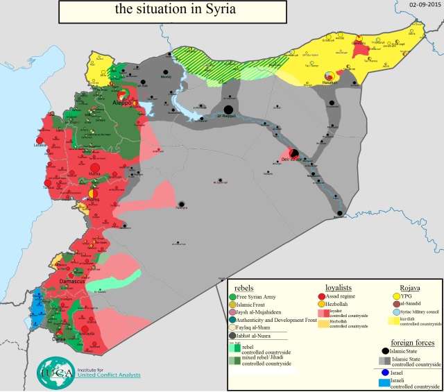
When children of his age were busy playing with gadgets, at 15 he started tracking and mapping war zones after watching the news coverage of the Egyptian revolution in 2011. He started following trends in Libya and Syria and made his first map showing the situation for the YPG and Kurdish forces in Syrian Kurdistan in December 2013.
When he starts a new map, Thomas takes a large file of a blank map and uses Microsoft Paint to color it since “he is not very sophisticated with computers”. He then uses a map tool on Google Earth to make and edit shapes of controlling territories, which he replicates in the Paint file. The finished product is shared on Twitter.
His sources include Twitter, Facebook and YouTube. He Skypes with fighters on the front, corresponds with activists and charities and even gets messages from other cartographers. In all, he claims to use over 1,100 sources for his Syrian maps.
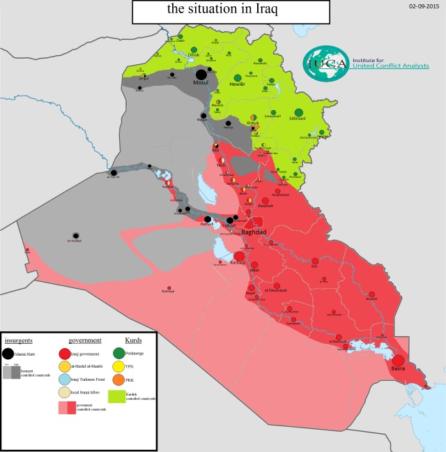
“When I see, for example, a status update of a rebel group on Facebook in which they claim they’ve captured a small village, then I usually wait until either other sources report it or footage from rebels within that village shows up on YouTube before I make the edit on my map,” he explained.
Apart from posting updated maps, he shares the news of ongoing humanitarian crises around the world. He posts photos of the aftermath of shelling and re-tweets activists who post graphic photos of children killed by weapons in Syria.
#RefugeeCrisis: a world of humanity compared to the world we live in…… #Aylan #SyrianRefugees pic.twitter.com/gqgaNV3BdK
— Thomas van Linge (@arabthomness) September 4, 2015
“By tweeting every bombardment, every victim of the Assad regime or ISIS, I believe you’re reminded of these crimes, these events. They’re ongoing everyday even though they don’t make headline news anymore,” he added.
What’s next for Thomas? According to Spiegel, he’s contemplating heading to one of the far-off lands he’s been mapping out to help the people suffering there in person.
This Article (Meet The Dutch Teen Who Maps ISIS From His Bedroom) is free and open source. You have permission to republish this article under a Creative Commons license with attribution to the author and AnonHQ.com.
")

if it is possible to follow “Thomas van Linge @arabthomness” on facebook, i would be interested in knowing.
Just do a FB search… (I Guess??) He’s on there.
All I can say is good job and may peace and justice prevail! Seriously dude you are one hell of a guy! Add me on facebook! Chris Alun Lloyd
Still telling one idea after another about ozone layer.
A troll post so obvious that even someone illiterate can detect the troll-shit.
Yet America and Nato have no idea where to find IS…….
Proud of you thomas! Keep up the good & imporatant job you are doing!!