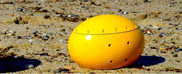
Sampriti Bhattacharyya, a PhD scholar at Massachusetts Institute of Technology (MIT), has invented and patented a football-sized underwater smart-drone named Evie (Ellipsoidal Vehicle for Inspection and Exploration) that can map ocean floors and underwater pollution, detect cracks or splits in nuclear reactor tanks, and search plane wreckage.
Hydroswarm, Sampriti’s tech startup created as part of her research thesis, has developed the drones for extensive underwater ocean exploration, data accumulation of unchartered ocean landscapes, locating lost equipment underwater, detecting mines and scan ship hulls for illegal drugs.
“Underwater navigation has been a reality for many years but for advanced searches you need maps that are as refined as, say, the Google map. This is where my drone comes in. It can map the ocean, sitting on its bed, and you can zero in on the minutest objects, living or non-living,” Sampriti told The Times of India.
The Guardian reports:
Evie uses a series of jets to propel itself through the water and maneuver in different directions. It includes a battery and various interchangeable sensors depending on what task the drone is carrying out. It could plug in electronics for monitoring the quality of water or for measuring pollution from an oil spill. Cameras can also be installed, although they will only work where natural light illuminates the water. Below that point, ultrasound sensors can be used to return images.
Sampriti, featured among Forbes’ top 30 most powerful young change agents of the world, says the small drones can work individually or together to either map different parts of the ocean or use sensors to detect abnormalities.
She told The Guardian:
“A group of the drones all individually fitted with hydrophones – microphones that can detect sound waves underwater – could be used to scan sections of the seabed. This swarm of devices would be a more cost-effective and practical approach than using larger and more expensive autonomous underwater vehicles (AUVs), robots which travel underwater.
“I was thinking that we don’t have the technology to find a massive 747 in the ocean and if you break down the physics of the problem, all you are searching for is a ping [from the black box]. And if you break it down further all you need to hear the ping is a cheap hydrophone.
“Why not have a network of distributed hydrophones over a large area that can all sync. Each of them has their own ID and location. If I hear a ping after a transmission, they all rise up. If any of them have heard it, they upload it [the details] to a satellite and you know where the ping is coming from.”
A sneak peak to the past. Eve the underwater drone evolves- short, tall,grande, venti 😉 @Starbucks @MassChallenge pic.twitter.com/586dVph6pt
— Hydroswarm (@hydroswarm) November 9, 2015
EVIE spans about eight inches across, and its plastic body is divided into two distinct hemispheres. The upper hemisphere contains a propulsion system of six water jets, which can push EVIE forward at about 2 miles per hour. The lower hemisphere is watertight and houses all the electronics, including a battery, motion sensors, central processor, wireless radio and a camera; the team flattened the bottom, so that EVIE could press flush against surfaces.
Hydroswarm can definitely help to change how we secure the ports. Thanks @govtechnews for mentioning us! http://t.co/a7bwXT5Xgu
— Hydroswarm (@hydroswarm) September 26, 2015
The prototype has already piqued the military’s interest. “I am particularly interested to see if this type of technology could find use in domestic maritime operations, ranging from the detection of smuggled nuclear, biological, or chemical agents to drug interdiction, discovery of stress fractures in submerged structures and hulls, or even faster processing and routing of maritime traffic,” Nathan Betcher, a special-tactics officer in the US Air Force, told MIT News.
Right now, the drones can go between 200 and 250 meters deep, but later versions will be able to go 1,000 meters under the surface. A consumer version of the drone is also planned that will operate like aerial drones used often by skiers when skiing or in ground-controlled aerial photography. She also aims to map the Mariana Trench, the deepest part of the world’s oceans – at 11 kilometers deep.
#MCAlum @hydroswarm is on a mission to better map the real final frontier: the oceans: https://t.co/duoionQXNd via @Forbes #30Under30
— MassChallenge (@MassChallenge) January 14, 2016
Watch Hydroswarm’s MassChallenge Testimonial! https://t.co/W9Po2RPEKv
— Hydroswarm (@hydroswarm) December 3, 2015
The underwater drones from @hydroswarm are set to revolutionize maritime commerce. See how at #MCAwards15: https://t.co/sqV9T59uQp
— Hydroswarm (@hydroswarm) October 28, 2015
This Article (MIT Student Creates Underwater Drone That Can Map Ocean Floor, Search Plane Wreckage) is free and open source. You have permission to republish this article under a Creative Commons license with attribution to the author and AnonHQ.com.


